B) Celtic tribes
In Celtic times, Gaul, Britain and Ireland were a patchwork of different communities or tribes, who were not politically or militarily united: each tribe was ruled by a chief – for example Ambiorix, leader of the Eburones, or Ambigatos, king of the Bituriges - and had its own specific organisation. However, despite their political disunity and diversification, the Celtic peoples were linked by economic ties and shared common linguistic, cultural, artistic, societal and religious values. The tribes lived on a territory delimited by frontiers which were generally natural, such as a river, a forest, a mountain, etc. Even though a certain number of tribes remain unrecorded, many of them are identified by the evidence of archaeology and the statements of Classical authors, notably Julius Caesar in his 1st-century BC Gallic Wars, the Greek geographer Strabo in his late 1st-century BC or early 1st-century AD Geography, the Latin historian Tacitus in his 1st-century AD Annals and Histories, and the Greek geographer Ptolemy in his 2nd-century AD Geography.
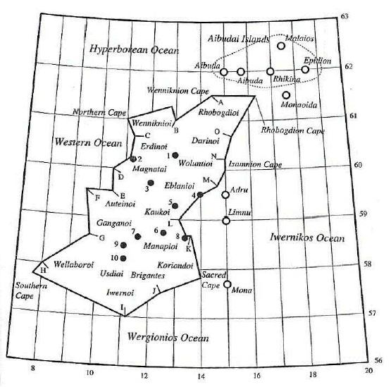
The name and location of the around twenty Celtic tribes settled in Ireland about the 1st c. AD are given by Ptolemy (fig. 3): in the north-east, the Rhobogdii; in the north-west, the Vennicnii; and in the west, the Nagnatae, settled in today’s Co. Mayo, the Autinni and the Gangani near the River Shannon, and the Vellabri in the area of present-day Co. Kerry.16 The south was occupied by the powerful tribe of the Iverni, later called Erainn, who gave their name to Ireland (Erin) and are generally regarded as being at least partially decended from the first Celtic people to have settled in Ireland around the 5th c. BC.17 The Brigantes, who were certainly an off-shot of the potent British Brigantes tribe settled in Yorkshire (GB), inhabited the south-east of Ireland.18 Finally, in the east, from south to north, six peoples are mentioned: the Coriondi, the Menapi, the Cauci, settled near Dublin, the Eblani, who were probably the ancestors of the Ulaid, and the Darinii.
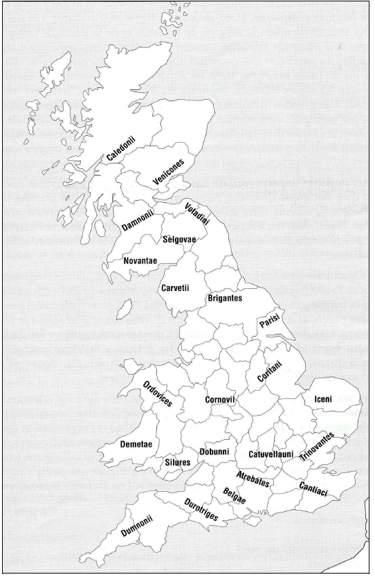
In Britain, about thirty Celtic tribes are recorded by Strabo, Tacitus and Ptolemy (fig. 4).19The powerful Brigantes sept* occupied the present-day counties of Yorkshire and Northumbria. They were ruled between 50 and 70 AD by the famous Queen Cartimandua, who, contrary to her husband Venutios, became allied with the Romans and handed her people over to them.20 The potent Ordovices tribe was situated in North Wales to the south of Anglesey, and was neighboured to the south by the Demetae and to the east by the Cornovii (in the Severn Basin).21 In the south-west and centre were settled the Dobunni, between Bristol Channel and the River Severn, and the Belgian Catuvellauni and Atrebates tribes, respectively situated to the north and south of the Thames.22 The Iceni tribe, led by the celebrated Queen Bouddicca, who, with the help of the Trinovantes, raised a revolt against the Roman invasion in 60 AD, inhabited present-day Norfolk and Suffolk.23
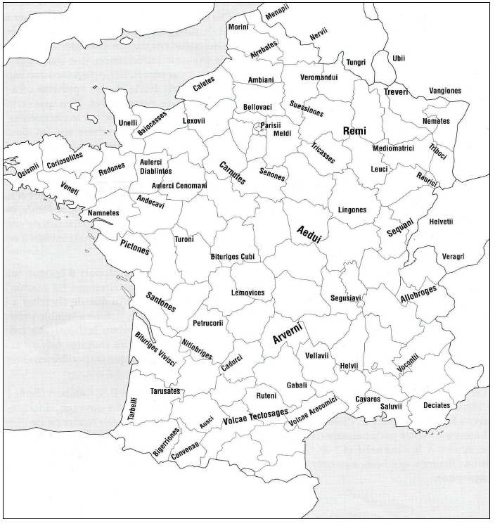
In Gaul, about sixty tribes have been reported, not counting the unrecorded septs* and the tribes of the Narbonese region, annexed earlier by the Romans in 125 BC. The most powerful were the Allobroges, the Sequani, the Lingones, the Aedui, the Arverni, the Remi, the Treveri, the Carnutes, the Pictones, the Santones and the Volcae (fig. 5). The Sequani inhabited the present-day regions of Franche-Comté and Burgundy, and were neighboured to the east by the Helvetii of today’s Switzerland and to the west by the Lingones, who inhabited the area of Langres (Haute-Marne), and by the Aedui, who had their territory between the River Saône and the river Loire.24 The powerful sept* of the Arverni dwelled in the present-day region of Auvergne and had their stronghold at Gergovia, near Clermont-Ferrand (Puy-de-Dôme), while the Allobroges occupied a vast territory situated between the Alps and the départements of Isère and Rhône.25 The Remi exercised their power over the region of Champagne, and were neighboured to the east by two smaller tribes: the Mediomatrici, living in the département of Moselle, and the Leuci, inhabiting the area of Toul (Meurthe-et-Moselle).26 To the north-east of the Remi, in present-day Luxembourg, were settled the potent Treveri, who had Titelberg as their chief oppidum*.27 As for the Carnutes, they inhabited a vast territory in the centre-west of Gaul, while the Pictones and the Santones were settled on the south-west coast, in the present-day Poitou and Charente-Maritime, and the Volcae Arecomici and Tectosages in the départements of Gard, Hérault, Tarn and Haute-Garonne.28